
Bolivia deployed the first automatic hydro-meteorological
monitoring buoy in Lago Menor del Titicaca
on June 28, 2019
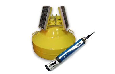
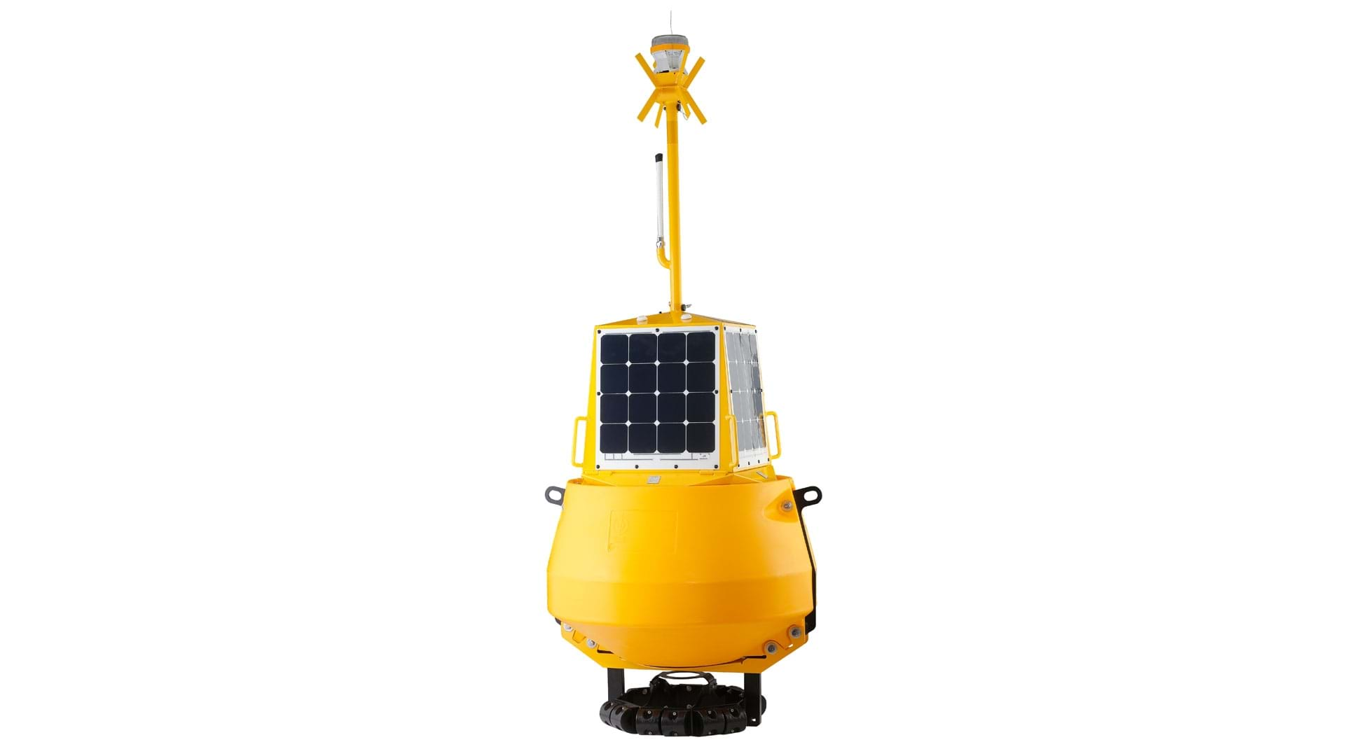
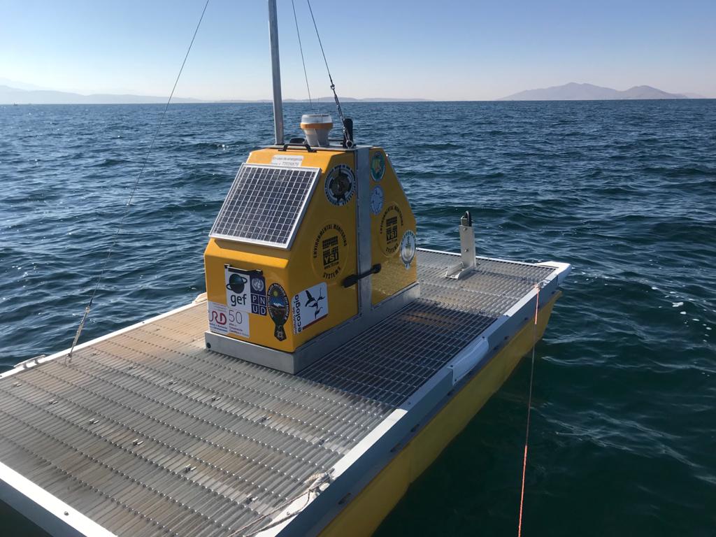
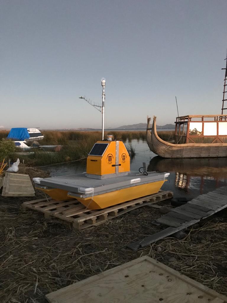
On Thursday June 27, 2019, a truck unloaded two huge boxes on a beach in Huatajata containing more than a ton of latest-generation electronic equipment. A group of university specialists, Dr. Xavier Lazzaro, researcher at IRD-France, MSc. Viviana E. Cruz Hernández, William G. Lanza Aguilar and Javier A. Maldonado Alfaro, young associate researchers from the Institute of Ecology (IE) and the Institute of Geographical Research (IIGEO) of the UMSA, with the technical support of Eng. Pierre Sterling, director of sales for manufacturer XYLEM Analytics Inc./USA for Central and South America, will assemble and deploy the first autonomous buoy-platform for automatic monitoring with high frequency of Lake Titicaca's water quality and weather conditions!
Why an automatic autonomous buoy?
Lake Titicaca Minor, especially its shallow coastal areas, is strongly impacted by the effects of climate change and human activities, especially domestic and industrial pollution from the city of El Alto, through the river basin Katari and Cohana Bay.
Global warming, the contributions in nitrogen, phosphorus and organic matter alter the biogoechemical and ecological functioning and aquatic biodiversity, endangering the species that are mostly endemic (native or local) of the Altiplano. Constant supply of nutrients and organic matter increases the productivity level of the lake's algae. In fact, with such intense solar radiation at almost 4,000 m above sea level, phytoplankton microalgae, during the day through photosynthesis, are the first to benefit from the supply of nutrients, increasing their biomass and oxygenating the water column. These primary producers are the base of the aquatic food chain. Bacteria mineralize organic matter and, on the contrary, consume dissolved oxygen. Some can produce toxic gases, as is the case with reducing sulfate bacteria that produce a powerful neuro-toxic gas, hydrogen sulfide (H2S), with the smell of rotten eggs.
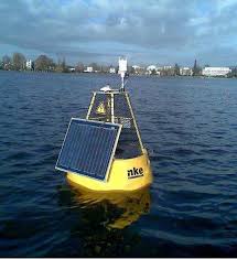
Set sail from the hydro-meteorological buoy on the shore of Huatajata.
At night, the respiration of consumers (zooplankton, macro-invertebrates, fish, among others) also depletes oxygen, which can become limiting in the early morning. Under extreme conditions, certain green microalgae and cyanobacteria can proliferate. They form a surface layer (‘bloom’) that does not allow solar radiation to pass in depth and inhibits the exchange of oxygen with the atmosphere. Lack of background light impairs the survival of submerged plants (macrophytes), such as charas, which also consume nutrients and oxygenate the water. Around, the reduction of dissolved oxygen, already reduced by 30% by height in relation to sea level, is deadly for these consumers.

Diagram of the conditions of the Minor Lake of Titicaca: A) Undisturbed conditions: Phytoplankton not abundant on the surface, submerged charas in good condition, good oxygenation (O 2 ). B) During the acute eutrophication event of 2015: massive contributions of nutrients (NO 3 , PO 4 ), proliferation of phytoplankton (green surface layer), deoxygenation, increased carbon dioxide (CO 2 ), release of hydrogen sulfide (H 2 S) toxic to aquatic life, collapse of Charas
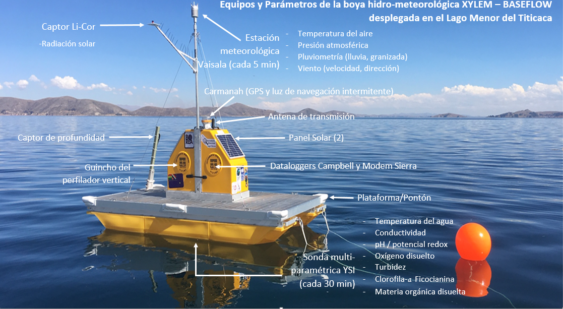
The evolution of this subtle balance of processes deserves to be studied to anticipate future lake responses, and to develop measures to control undesirable phenomena. For this, the behavior of key parameters in the water needs to be monitored / monitored. The most important are: the concentration in dissolved oxygen (-), the temperature gradient (+) (the increase in temperature reduces the solubility of oxygen), the concentration in dissolved organic matter (+), the transparency (-) or turbidity (+), pH (+), chlorophyll-a concentration, the highest photosynthetic pigment in algae (+), the proportion and concentration in cyanobacteria in phytoplankton (+), conductivity (+). Increasing (+) or decreasing (-) these parameters reveals a deterioration in water quality, called ‘eutrophication’. This does not take into account the pollutants themselves. These parameters are influenced by atmospheric conditions, such as: the force of the wind capable of mixing and cooling the water column, the intensity of solar radiation (altered by cloudiness) that warms the surface, the atmospheric pressure that regulates the dissolution of the oxygen, rainfall (rain, snow, hail) that provides nutrients, among others. The responses of microorganisms (micro-algae, bacteria) to variations in environmental conditions are extremely fast. They are able to double their densities in hours or days. Measurement campaigns and sample collections are time consuming, require logistics (vehicle, ship, equipment) and are expensive. They can only be done 1-2 times a month, and part of the year. It is insufficient to anticipate the dynamics of these organisms and the eutrophication phenomena. For this reason, it is necessary to complete the regular campaigns in some representative stations with automatic high-frequency sampling in the entire water column in a central station that integrates the variability of conditions in the area of interest. Advances in technology, improved sensitivity and miniaturization of sensors, reliability of probes, robotics, computer programming, Internet, speed and coverage of the cellular network, greater efficiency of solar panels, now allow the design of platforms perfectly autonomous and automatic. The buoy deployed in Lake Menor is the example. The transmission of data via ENTEL's cellular network to our servers at UMSA in La Paz, allows us to have an almost real-time view of the lake, being able to take action if necessary. With this technology, Lake Titicaca is now instrumented (equipped) like most of the other Great Lakes in the World.
Where is 'My Buoy' Located?
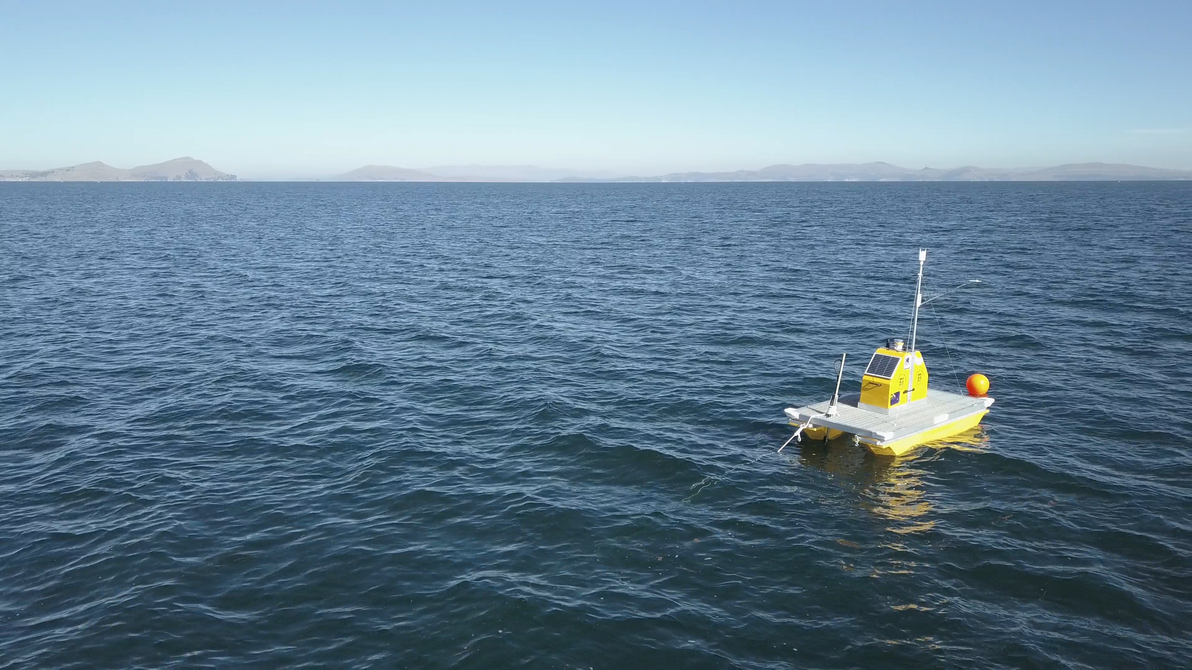
The Northeast region is the shallowest, most populated region of Lake Menor, where the proliferation of phytoplankton micro-algae occurred in April-May 2015. In this region, the daily heating of the shallow body of water invariably causes thermal winds that increase its intensity in the early afternoon. They can reach speeds of up to 10 m / s, enough to mix the water column up to 5 m deep. This mixture causes the resuspension of the nutrients and organic matter deposited in the bottom. This phenomenon makes this region the most favorable in generating proliferations (‘blooms’) of micro-algae of the phytoplankton. For this reason, she was chosen to deploy the buoy. It is anchored at a depth of 13 m, possibly in the northern branch of the Katari river, in an area of 8 m depth on average. This location allows studying the dynamics of daily vertical gradients in dissolved oxygen, temperature, organic matter and chlorophyll-a, generated by meteorological conditions.
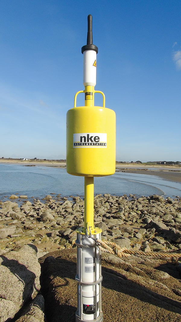
‘Location of the buoy in the northeast region of Lago Menor del Titicaca, Bolivian sector, 4 km south of Huatajata and 10 km west of Puerto Pérez’
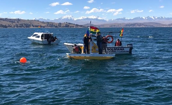
The inaugural Lacustrine Ceremony of 'My Buoy'.
To present 'My Buoy' and its operation to State institutions, local authorities and riverside populations, an inaugural Lake Ceremony was organized on Friday, June 28, 2019. As this Buoy measures both hydrobiological and meteorological parameters, it was called 'HidroMet' buoy in technical language. For the general public it is ‘Mi Boya’ because it is a heritage of the inhabitants of the Lake that informs them of their state of health. It also has its Aymara name ‘Qamaskiua ch’uwa quta mama’, chosen by the riparians themselves.
The welcoming words were given by Eng. Isaac Callizaya Limachi, Secretary of Environment and Cultures of Puerto Pérez. Representatives of the Institutes of Ecology (IE), Hydraulics and Hydrology (IHH), Chemical Investigations (IIQ) and Geographical Investigations (IIGEO) of the UMSA, the Operational Unit of Bolivia (UOB), the Katarí Basin Management Unit participated. (UGCK) and the General Directorate of Planning (DGP / UEE) of the MMAyA, Mr. Grover Huallpa Aruquipa, coordinator of the IWRM project at the Bolivian Chancellery (MRE), Mr. Rolando Urahola, Director of the Decentralized Public Institute of Fisheries and Aquaculture (IPD-PACU) for the Altiplano, technicians from the National Service of Meteorology and Hydrology (SENAMHI), the communicator of the La Vida project, Eng. Valentin Fernández, Director of the ALT Master Plan and technicians, Prof. Eliana Ballivian Ríos, communicator of the IWRM project, Prof. Analía Guachalla Terrazas, coordinator of the technical liaison for Bolivia, Eng. Gonzalo Lora Viezaga, ex-binational scientific coordinator of the IWRM project, Mr. De nis Gaillard, Ambassador of France in Bolivia and Mr. Patrick Riba, Head of French Cooperation, Eng. Cenaida Ramos Poma, representing the National Water Agency in Puno Peru, Arch. Hugo Zea Giraldo, coordinator of the QOTATITI platform of the Peruvian society, the local authorities of Puerto Pérez, Mr. Felix Mendoza Secretary General of the Quehuaya Island, Mrs. Virginia Mamani of the Isla Suriqui Bartolina Sisa Agrarian Central, from Huatajata and Tiquina, with journalists from the press : Canal 13 TV Universitaria, RTP Bolivia, the Foundation for Strategic Investigation in Bolivia (PIEB), the Association of Journalists of La Paz, and France 24. On Google, view notes and video reports, with the words 'Titicaca buoy'.
Next to the buoy, Comadre Adela, Copacabana Spiritual Guide, held an ancient lake ceremony of good omens for the team, participants, institutions, research projects, monitoring and restoration of the Lake. Mr. Lorenzo Inda, Uru representative in Desaguadero, welcomed on the floating totora island of Quehuaya, communicating the concern of the coastal towns regarding the increasing contamination. In total there were 60 participants, aboard 3 boats piloted by Messrs. Natalio and Ariel Esteban, from Suriqui, and Máximo Catari Cahuaya from Huatajata.
‘Inaugural lake ceremony demonstration of My buoy,…’
The Bolivian Navy supported with a ship from the Huatajata Captain's Navy. On board the buoy, Ing. Sterling and Dr. Lazzaro, described the technical characteristics of the buoy, the parameters to be measured, the frequency of data acquisition, what it is for, the benefits for the inhabitants, scientists and decision makers, and why was it deployed in this area? Due to the strong waves and wind, it was not possible to show the operation of the different internal elements of the buoy, such as the vertical profiler and the multiparameter probe. Despite the use of megaphones, it was difficult to communicate with the audience on the boats. For this reason, after a trial period of about two months, another technical workshop will be organized on the Cota Cota UMSA Campus, to train teams from the UMSA, MMAyA, SENAMHI and ALT, among others.